
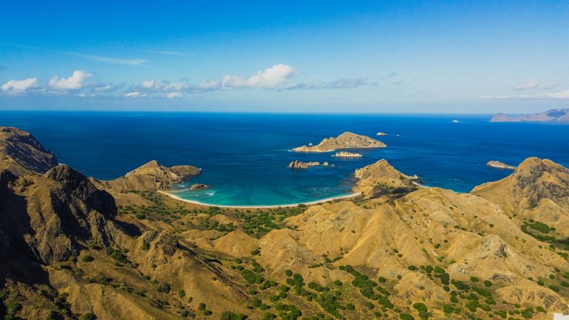
UNESCO, which inscribed Komodo National Park as a World Heritage Site in 1991, describes the park as made up of three major islands, Rinca, Komodo and Padar, and numerous smaller ones.
This page is a short index of the Komodo islands and some of the smaller places in the park: what each one is, and which of our guides covers it in full. For park-wide information, see our Komodo National Park guide.
The three main islands
The park authority, Balai Taman Nasional Komodo, states that Komodo dragons live naturally in the park. According to the park authority’s history of the park, each of the three main islands was protected as a wildlife sanctuary before the national park was designated in 1980.
Komodo Island
Komodo is one of the three major islands named by UNESCO. It was designated a wildlife sanctuary in 1965. The park authority lists Loh Liang as a trekking destination. Our guide to Komodo Island covers what a visit involves, including Loh Liang on Komodo Island.
Padar Island
Padar is the third-largest island in the park, according to Indonesia’s Ministry of Tourism. It was designated a wildlife sanctuary in 1938, and the park authority lists Padar Selatan as a trekking destination. Our Padar Island guide explains what the climb involves.
Rinca Island
Rinca was designated a wildlife sanctuary in 1938, alongside Padar. The park authority lists Loh Buaya as a trekking destination. Our guide to where Komodo dragons can be seen covers the dragon side of a visit, including Loh Buaya, on Rinca.
Other places in the park
The places below appear among the tourism destinations listed on the park authority’s website, which was last updated in May 2026. Each is listed with the activities the park authority gives for it.
Pink Beach
The park authority lists Pink Beach for sunbathing and snorkelling. The beach is known for the pink tint of its sand. Snorkelling conditions across the park are covered in our guide to snorkelling in the park.
Taka Makassar
Taka Makassar is listed by the park authority for snorkelling and diving. Indonesia’s public broadcaster RRI described it in June 2026 as an uninhabited, crescent-shaped sandbar that fully emerges only at low tide and is covered by water at high tide.
Gili Lawa
Gili Lawa is listed by the park authority as “Gililawa” for trekking and snorkelling. In August 2018, the then head of the park, Budi Kurniawan, described Gili Lawa Darat as part of the park and a tourist area with savanna, as reported by Tempo. That statement dates from 2018; the sources used for this article do not independently confirm the description today.
Kalong
Pulau Kalong is listed by the park authority for wildlife watching. A Ministry of Tourism directory describes it as a small island in the park inhabited by bats. CNN Indonesia also placed Pulau Kalong in the park in a 2022 report. The name itself means bats, according to the Ministry of Tourism.
Manta rays and “Manta Point”
A peer-reviewed study published in PeerJ in 2022 identified 1,085 individual reef manta rays from photographs collected between 2013 and 2018. The study found that the rays used sites within the park for foraging, cleaning, cruising and courtship. Its figure is a count of individuals identified over that period, not an estimate of the current population.
Separately, the national news agency ANTARA reported in May 2017 that Manta Point is a well-known dive spot in the Komodo National Park area, and placed it around Rinca Island. The study above does not use the name “Manta Point”, and this page does not connect the two.
Islands near Labuan Bajo
This page covers the three major islands and selected destinations listed by the park authority. Islands near Labuan Bajo are covered in a separate guide.
Frequently asked questions
UNESCO describes the park as made up of three major islands, Rinca, Komodo, and Padar, and numerous smaller ones.
Pink Beach, Taka Makassar, Gili Lawa, and Kalong, which appear among the destinations listed by the park authority. It also includes a short note on manta rays and the name “Manta Point”.
Leave a reply