Kelimutu is a volcano in central Flores, Indonesia, whose summit holds three crater lakes known for changing colour. It lies inside Kelimutu National Park, and visits depend on the volcano’s alert level and on decisions by the park authority. This guide explains what the lakes are, why their colours change, how access works and how to reach the area, using information from Indonesian government agencies and the Smithsonian Institution.
What Kelimutu is
Kelimutu rises in Ende Regency, in the centre of Flores island in East Nusa Tenggara. The Smithsonian Institution’s Global Volcanism Program gives its summit elevation as 1,639 metres and classifies it as a complex volcano with three summit crater lakes, although Indonesian reports often call it a stratovolcano. The programme lists three confirmed eruptive periods, the most recent in 1968.
The volcano and the land around it form Kelimutu National Park, established in 1992 under forestry ministry decree SK No. 279/Kpts-II/92. The park covers about 5,356.5 hectares and is often described as Indonesia’s smallest national park.
The name is commonly explained as a combination of two local words: keli, meaning “mountain”, and mutu, meaning “boiling”.
The three lakes and their names
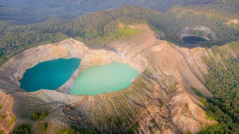
The three lakes lie in separate craters along the summit. Their names in the local language are:
- Tiwu Ata Bupu (also spelt Ata Mbupu), often translated as the “Lake of Old People”, the westernmost of the three;
- Tiwu Nuwa Muri Ko’o Fai (also spelt Koo Fai), the “Lake of Young Men and Maidens”;
- Tiwu Ata Polo, the “Bewitched” or “Enchanted” Lake.
Tiwu Nuwa Muri Ko’o Fai and Tiwu Ata Polo lie side by side, separated by a shared crater wall.
The names reflect local belief. According to local tradition, the lakes are the resting places of the souls of the dead: the souls of the old are said to go to Tiwu Ata Bupu, the souls of the young to Tiwu Nuwa Muri Ko’o Fai, and the souls of people who did wrong in life to Tiwu Ata Polo. These are beliefs held by local communities, and they are separate from the scientific explanation of the lakes’ colours below.
No lake has a single fixed colour. Reports describe colours ranging from turquoise and green to red, brown and black, and each lake has changed more than once, so colours seen in older photographs and accounts may not match what a visitor sees today.
Why the lakes change colour
Indonesia’s Geological Agency (Badan Geologi) says volcanic activity is the main reason the lakes change colour. In July 2024, Irwan Ka Uman, head of the agency’s Kelimutu Volcano Observation Post (Pos Pengamatan Gunung Api Kelimutu), described one of the lakes shifting from light blue to a turquoise green. He said sulphur deposits on its surface, concentrated near the centre of the crater, suggested that magmatic fluids were rising and that a magmatic-hydrothermal system was active beneath the lake.
In plain terms, the lakes sit above a volcano that is still active, and the agency links changes in the fluids and gases reaching the water to changes in its colour. The agency does not point to a single cause such as rainfall or algae, and neither does this guide.
The changes are frequent. Kelimutu National Park data, reported by Mongabay Indonesia in 2016, recorded that between 1915 and 2011 Tiwu Ata Polo changed colour 44 times, Tiwu Nuwa Muri Ko’o Fai about 25 times and Tiwu Ata Bupu 16 times.
Volcano alert levels and park closures
Indonesia’s Centre for Volcanology and Geological Hazard Mitigation (PVMBG), part of Badan Geologi, rates each monitored volcano on a four-level scale set out in Ministry of Energy and Mineral Resources Regulation No. 15 of 2011:
- Level I, Normal: no increase in activity beyond the volcano’s usual pattern;
- Level II, Waspada (Advisory): activity has begun to rise above normal, but there is no direct threat to nearby settlements;
- Level III, Siaga (Watch): activity has clearly increased, or the volcano is erupting;
- Level IV, Awas (Warning): an eruption is under way or expected soon.
When the level rises or conditions change, the park authority (Balai Taman Nasional Kelimutu) can restrict or close access. Two recent examples show how this works:
- 2024: PVMBG raised Kelimutu to Level II on 24 May 2024, and the park restricted visits while the level was raised. After PVMBG lowered the level on 23 September 2024, the park reopened for visits from 25 September.
- 2026: the park closed for several days in August 2026 after a strong earthquake, then reopened with shortened hours. The volcano’s alert level stayed at Level I throughout.
The second example shows that the park can close for reasons other than the alert level, such as an earthquake or damage to the crater walls. Because conditions change, check the park authority’s official announcements and PVMBG’s volcano bulletins shortly before you travel.
At the time of writing (November 2026): Kelimutu was at Level I (Normal). The park had restored its usual opening hours of 04.30–16.00 WITA, so sunrise visits were possible again. The viewpoint over Tiwu Ata Polo remained closed after a crack opened near the crater rim in the August 2026 earthquake; the other viewpoints were open. Conditions can change at short notice, so check the sources above before you go.
At the site: viewpoints and paths
A visit centres on the viewpoints over the lakes, reached on foot from the car park. The Ministry of Tourism notes that visitors can walk around the lakes only in part, because some areas are dangerous and closed. At the time of writing, one viewpoint was closed after the August 2026 earthquake, as the status note above explains.
No official source found describes other facilities at the site, such as toilets or food stalls, so this page does not list any.
Visiting the crater rims safely
The crater walls are steep, and landslides happen. A landslide on a crater wall on 4 August 2026 led the park to issue an announcement, and the site stayed open while the volcano remained at Level I.
After the earthquake of 15 August 2026, a crack about 100 metres long opened near a crater rim. Badan Geologi advised visitors not to go near it and to keep 6–10 metres back from the crater rim. That was advice issued after the earthquake, not a permanent rule.
The park’s own rules for visitors are:
- stay on the official trails;
- do not cross fences or barriers;
- do not light fires or leave cigarette ends;
- take your rubbish with you.
Health and safety points that apply across the whole region are covered in general travel health and safety advice for the region.
Getting there: Ende, Maumere and Moni
Flores is a long island, and Kelimutu sits near its centre. Travellers who begin a Flores journey in Labuan Bajo, at the western end of the island, arrive through Labuan Bajo’s airport, and Kelimutu lies a long way east of it.
The nearest airport to Kelimutu is H. Hasan Aroeboesman Airport in Ende. Maumere, further east, is another gateway to the area. Kelimutu can also be reached by road across Flores. How that road is divided into legs is explained on the Trans-Flores route page.
Indonesia’s Ministry of Tourism describes Moni as the nearest small town, at the foot of the volcano, and the gateway to the lakes; many visitors base themselves there. It places Koanara village, the closest village to the volcano, about 66 km from Ende and 83 km from Maumere, and says buses between Ende and Maumere pass through Moni.
From Moni, visitors go up by motorbike taxi (ojek), car or public transport to a car park below the summit, then walk for about 30 minutes to the viewpoints. The Ministry gives about 11 km by road to the car park, but its figures for the distance from Moni to Kelimutu differ on the same page, about 12 km in one place and 15 km in another, so treat them as approximate. The same page notes a walking path from Moni that is shorter than the road.
Opening hours are set by the park, so check them before planning an early start.
Frequently asked questions
The name is commonly explained as combining two local words: keli, meaning “mountain”, and mutu, meaning “boiling”. Together they are usually read as “boiling mountain”.
Indonesia’s Geological Agency says volcanic activity is the main reason. It links changes in the fluids and gases reaching the lakes from the volcano beneath to the changes in colour. Park data show that each lake has changed colour many times over the past century.
The lakes are seen from viewpoints on the rim, not from the water. Visitors are asked to stay on the official trails and not to cross fences or barriers, and the crater walls are steep and have seen landslides. Anyone unsure about a specific activity should ask the park authority.
Access depends on the volcano’s alert level and on decisions by the park authority, and it has been restricted or closed before, in 2024 and in August 2026. Check the park authority’s announcements and PVMBG’s volcano bulletins shortly before you travel.
The park sets its own opening hours, and they have changed after volcanic or seismic events. At the time of writing (November 2026), the usual hours of 04.30–16.00 WITA had been restored. Check the park authority’s announcements for the current hours.
Fly to Ende or Maumere, or travel overland across Flores, then continue to Moni, the small town at the foot of the volcano. From Moni, an ojek, car or public transport goes up to a car park, and the viewpoints are about 30 minutes on foot, according to Indonesia’s Ministry of Tourism.
Many base themselves in Moni, which Indonesia’s Ministry of Tourism describes as the nearest small town and the gateway to the lakes.